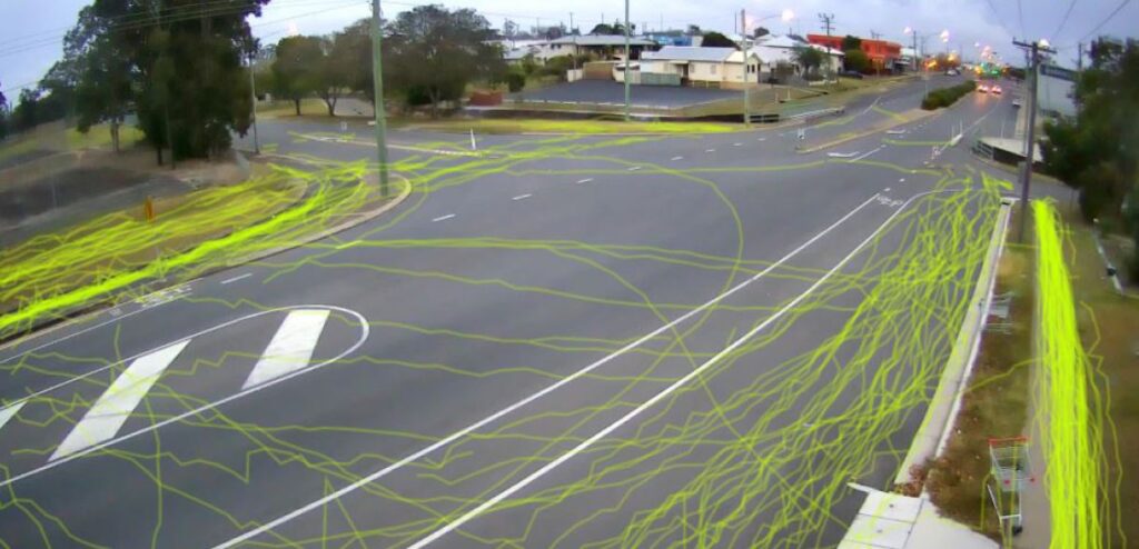
Artificial intelligence is being used to map when and how pedestrians are using roads and pathways to plan future upgrades around current use and demand in the Bundaberg Region.
Bundaberg Regional Council Roads and Drainage portfolio spokesperson Cr Bill Trevor said the innovative and strategic approach to developing the region’s transport options for pedestrians and cyclists was not only more accurate but more cost effective as well.
“This emerging technology is no small improvement in our practices, it’s a quantum leap,” Cr Trevor said.
“Previously, the only way we have been able to collect this information is manually.
“That means having a person standing on a pathway and clicking a counter every time they see a pedestrian.
“It’s not as reliable and, if traffic increases at one particular time, they can’t necessarily keep an accurate track of movement.”
The cameras capture imagery and use it to track the route that was taken.
Using artificial intelligence the software can further break this data down into transport categories including pedestrian, cyclist, motorbikes and even differentiates between cars, utes, taxies, buses and trucks.
The end result is a single image which shows pedestrian and vehicle movement as ‘tracelines’ for the final report, with each individual movement identified only by a colour which represents the mode of transport.
The technology was trialled within the region and Cr Trevor said it was the results of that trial which saw Council decide to continue its use of the technology for future planning.
“This new technology automates the data collection process but it also gives us access to more information than ever before.
“We don’t just know that someone used the footpath, we know what mode of transport they used, where they crossed the road and which direction they went.
“This can have tangible benefits in the planning process.
“For instance, if we had plans to provide a pedestrian refuge at a particular point but from the data we can see most people travel from the opposite direction and cross 200 m away, they’re not likely to walk the extra distance to use that pedestrian refuge.
“It’s all about trying to provide best practice engineering solutions while making informed decisions based on behaviour.”
The artificial intelligence software will be utilised over coming months at several sites to assist in transport planning and refining the location of footpath and cycling infrastructure based on measured demand.
More Council news: Development incentive scheme set to grow region


